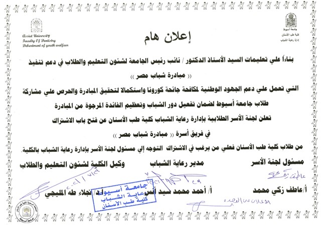
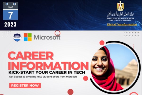
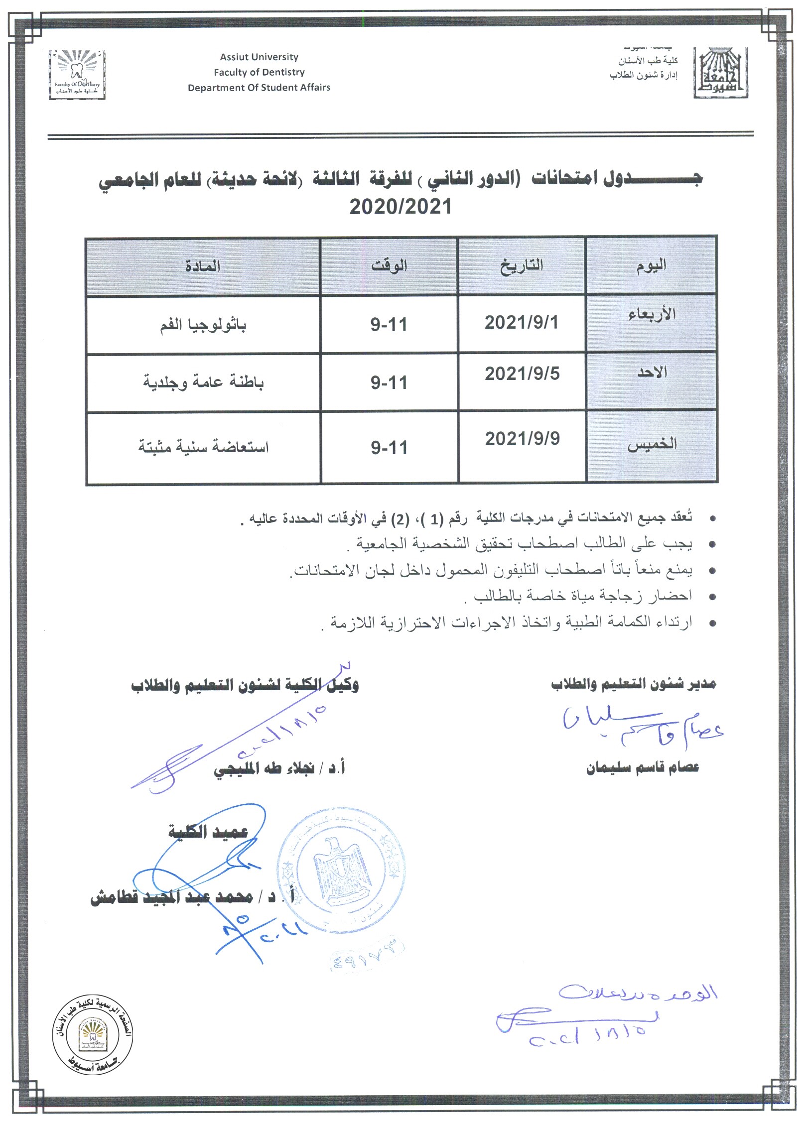
Gravity based assessment of spatio-temporal mass variations of the groundwater resources in the Eastern Desert, Egypt

Research Abstract

Gravity Recovery and Climate Experiment (GRACE) data with other data sets are used to estimate the mass variations over the Eastern Desert. These variations are caused by changes in terrestrial water storage (ΔTWS). Monthly GRACE and Mascon Solutions with other relevant data are conducted. Findings are (1) the Eastern Desert is witnessing a dry climatic period (April 2002 to July 2012) with lower average annual precipitation (AAP) rate of 9.3 mm and a wet climatic period (August 2012 to July 2016) with slightly higher precipitation rate of 14.1 mm; (2) the average trends in ΔTWS over the study area are estimated at − 4.40 ± 0.63 mm/year and + 4.37 ± 20.7 mm/year during the dry and wet periods, respectively; (3) the spatial distribution of the ΔTWS values during the wet period are consistent with the distribution of the rainfall, and the water leakage from Lake Nasser towards the surroundings though fault conduits; (4) the groundwater storage variation (ΔGWS) shows a negative trend of − 3.95 ± 0.63 mm/year during the dry period, while it shows a positive trend of + 4.98 ± 2.00 mm/year for the wet period; (5) Lake Nasser shows slightly higher water level variations during the wet period, in comparison to that of the dry period; (6) the surface water is draining eastward into the Red Sea and westward into the Nile River and partially feeding the underground aquifers through the permeable outcrops and/or along the sub-vertical deep-seated faults. Results provide new information on the mass variations of the Eastern Desert, caused by the change in the water storage in response to the climatic variation and global warming. The lowlands of the main valleys may represent the promising areas for agricultural development in the Eastern Desert.

Research Authors
Ahmed Mohamed, Esraa Ragaa Eldeen, Karim Abdelmalik
Research Date
Research Journal
Arabian Journal of Geosciences
Research Pages
1-15
Research Rank
1
Research Vol
14 (6)
Research Year
2021

Investigation of groundwater occurrence using gravity and electrical resistivity methods: a case study from Wadi Sar, Hijaz Mountains, Saudi Arabia

Research Abstract

An integrated approach of Gravity Recovery and Climate Experiment (GRACE) and vertical electrical resistivity sounding (VES) technique has been carried out to investigate regionally and locally the groundwater potentialities of Wadi Sar in the Hijaz Mountains. Our findings are (1) the terrestrial water storage variations (ΔTWS) are estimated at −2.06±0.34 mm/year; (2) the Global Land Data Assimilation System–derived soil moisture storage variations (ΔSMS) are estimated at −0.067±0.005 mm/year; (3) the groundwater storage variations (ΔGWS) show a negative trend estimated at −2.00±0.34 mm/year during the period April 2002–July 2017; and (4) the average annual precipitation (AAP) rate is estimated at 115 mm during the period 2002–2018. Three geoelectrical layers are identified from the inversion of the electrical resistivity data: (5) the surface layer of high resistivity values is consisted of dry unconsolidated Quaternary deposits; (6) the second layer represents the fractured groundwater aquifer of low resistivity values and variable thickness; (7) the third layer is composed of fractured basement rocks of higher resistivity values. The streams are draining the surface water toward the Najd Pedi plain aquifer; (8) the faults are acting as conduits for groundwater flow away from the Wadi. The current study indicates the occurrence of groundwater at the downstream zones of the Wadi Sar, but with a general decrease trend. The integrated approach provides a better understanding of the groundwater potentialities in the arid regions.

Research Authors
Ayman I Taha, Mohamed Al Deep, Ahmed Mohamed
Research Date
Research Journal
Arabian Journal of Geosciences
Research Pages
1-10
Research Rank
1
Research Vol
14 (5)
Research Year
2021

Hydro-geophysical monitoring of the North Western Sahara Aquifer System's groundwater resources using gravity data

Research Abstract

The North Western Sahara Aquifer System (NWSAS) is characterized by unsustainable groundwater exploitation whose magnitude depends on the still unclear recharge value. It is extending over Libya, Tunisia, and Algeria, with an area of 106 km2. Here, we proposed an integrated approach combining Gravity Recovery and Climate Experiment (GRACE) and Global Land Data Assimilation System (GLDAS) data to reconstruct groundwater storage variations (ΔGWS) between April 2002 and July 2016. ΔGWS values are then introduced in a regional water budget equation accounting for the temporal evolution of withdrawals and natural discharge to calculate the time variations of the recharge. Yearly reconstruction of the recharge shows a large variability with alternation of net positive recharge and periods of net diffuse discharge associated with evaporation. The temporal average effective recharge value for the period of interest is 1.76 ± 0.44 mm yr−1. Lag-times for the recharge to reach the water table of 45 and 100 yrs characteristic of a diffuse recharge and corresponding vadose thickness in the range 3.90 ± 3.60 and 8.60 ± 8.10 m were identified using a cross-correlation analysis between reconstructed annual recharge and annual rainfall (AR). Statistical interpretation of the relation between ΔGWSAR, and withdrawals shows that the anthropogenic effect (groundwater extraction) is the main controlling factor (99% of explained variance) in comparison to AR variations for the ΔGWS time series under consideration. A relation between long-term recharge and average annual rainfall (AAR) suggests a recharge representing 1.8 ± 0.3% of AAR in transboundary aquifers of the Saharan belt.

Research Authors
Ahmed Mohamed, Julio Gonçalvès
Research Date
Research Journal
Journal of African Earth Sciences
Research Pages
104188
Research Rank
1
Research Vol
178
Research Year
2021

Depth to the bottom of the magnetic layer, crustal thickness, and heat flow in Africa: Inferences from gravity and magnetic data

Research Abstract

Data from the Earth Gravitational Model (EGM2008) and the Earth Magnetic Anomaly Grid (EMAG2) were used to develop a continental scale crustal thickness model for Africa, and to estimate the depth to the bottom of the magnetic layer (DBML) and the geothermal gradient and heat flow. The results are: (1) the estimated DBML from the magnetic data varies from ~23.0 to ~37.2 km. The shallowest DBML values are located in the northern, eastern, and western parts of the continent, whereas the deepest values are observed in the central and southern regions. (2) The estimated crustal thickness based on gravity data varies from ~29.9 km in the northern and western parts of Africa to ~48.0 km in its southern regions, with an average thickness of 35.1 km for the whole continent. (3) The estimated heat flow varies between high values of 46–59 mW/m2, observed in the northern, eastern, and western regions to low values of ~< 41 mW/m2, observed in the central and southern parts of the continent. (4) The geothermal gradient values vary between 14.5 and 23.6 °C/km (5) The East African rift zone is underlain by shallow DBML characterized by high heat flow values that vary between 42 and 59 mW/m2 (6) The heat flow anomalies in Egypt and Libya may be associated with the zone of the Pelusium megashear system, and it shows heat flow values that vary between 36.3 and 59.0 mW/m2. The current study has taken advantage of the availability of the EGM2008 and EMAG2 datasets to map crustal thickness variations and DBML beneath the continental landmass of Africa.

Research Authors
Ahmed Mohamed, Mohamed Al Deep
Research Date
Research Journal
Journal of African Earth Sciences
Research Pages
104204
Research Rank
1
Research Vol
179
Research Year
2021
Subscribe to