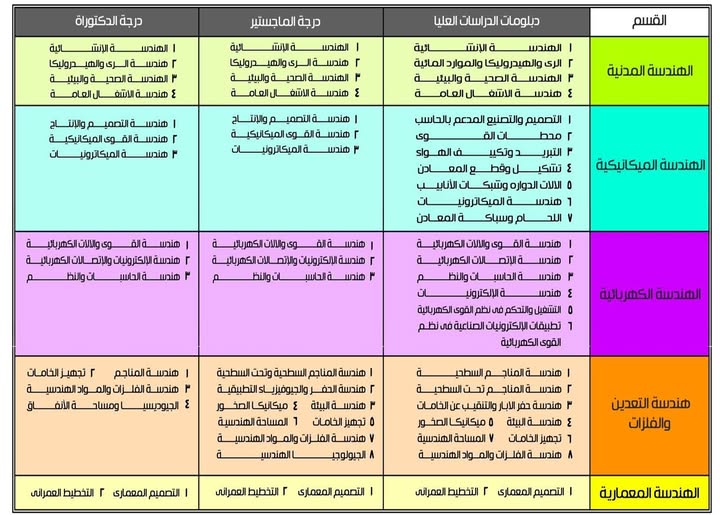
EnMap hyperspectral data in geological investigations: Evaluation for lithological and hydrothermal alteration mapping in Neoproterozoic rocks

Research Abstract

This study conducted a rigorous evaluation of Environmental Mapping and Analysis Program (EnMap) data in geological applications, specifically focusing on lithological and hydrothermal alteration mapping. This research represents one of the earliest attempts to apply EnMap data for such purposes, and the first to integrate EnMap and airborne geophysical data for geological mapping over the entire Arabian Nubian Shield. To ensure a comprehensive appraisal, we selected a study area characterized by complex Precambrian rocks, including igneous, metamorphic, and sedimentary formations, alongside structural intricacies and hydrothermal activities. Our study utilized various image-processing techniques, including principal component analysis (PCA), Uniform Manifold Approximation and Projection (UMAP), Sequential Maximum Angle Convex Cone (SMACC) endmember analysis, and spectral resampling. These techniques successfully discriminated ophiolitic serpentinite, volcaniclastic metasediments (as part of the ophiolitic mélange matrix), metavolcanics, metagabbro-diorite, syn-orogenic granite, post-orogenic granite, Nubian sandstone, and Wadi deposits. Additionally, they revealed the prevalence of OH-bearing minerals and iron oxides as the primary hydrothermal alteration products within the study area. By correlating the findings with USGS spectral libraries and airborne geophysical data, we determined the efficacy of EnMap data in these applications. Our findings were further validated through multiscale observations, field investigations, petrographic analyses, and scanning electron microscopy-energy-dispersive X-ray spectroscopy (SEM-EDX). In addition to endorsing the use of the UMAP algorithm and EnMap data for future applications, this study highlights key alteration zones that could serve as potential targets for future gold exploration, alongside insights into bauxite ore occurrences.

Research Authors
Ali Shebl, Mahmoud Abdellatif, Dávid Abriha, Maher Dawoud, Mosaad Ali Hussein Ali, Abdelhalim S Mahmoud, Ferenc Kristály, Árpád Csámer
Research Date
Research Journal
Gondwana Research
Research Member
Research Pages
91-124
Research Publisher
Elsevier
Research Rank
Q1
Research Vol
143
Research Website
https://www.sciencedirect.com/science/article/pii/S1342937X25001066
Research Year
2025

Groundwater Potential Mapping in Semi-Arid Areas Using Integrated Remote Sensing, GIS, and Geostatistics Techniques

Research Abstract

Groundwater serves as a vital resource for sustainable water supply, particularly in semi-arid regions where surface water availability is limited. This study explores groundwater potential zones in the East Desert, Qift–Qena, Egypt, using a multidisciplinary approach that integrates remote sensing (RS), geographic information systems (GIS), geostatistics, and field validation with water wells to develop a comprehensive groundwater potential mapping framework. Sentinel-2 imagery, ALOS PALSAR DEM, and SMAP datasets were utilized to derive critical thematic layers, including land use/land cover, vegetation indices, soil moisture, drainage density, slope, and elevation. The results of the groundwater potentiality map of the study area from RS reveal four distinct zones: low, moderate, high, and very high. The analysis indicates a notable spatial variability in groundwater potential, with “high” (34.1%) and “low” (33.8%) potential zones dominating the landscape, while “very high” potential areas (4.8%) are relatively scarce. The limited extent of “very high” potential zones, predominantly concentrated along the Nile River valley, underscores the river’s critical role as the primary source of groundwater recharge. Moderate potential zones include places where infiltration is possible but limited, such as gently sloping terrain or regions with slightly broken rock structures, and they account for 27.3%. These layers were combined with geostatistical analysis of data from 310 groundwater wells, which provided information on static water level (SWL) and total dissolved solids (TDS). GIS was employed to assign weights to the thematic layers based on their influence on groundwater recharge and facilitated the spatial integration and visualization of the results. Geostatistical interpolation methods ensured the reliable mapping of subsurface parameters. The assessment utilizing pre-existing well data revealed a significant concordance between the delineated potential zones and the actual availability of groundwater resources. The findings of this study could significantly improve groundwater management in semi-arid/arid zones, offering a strategic response to water scarcity challenges

Research Authors
Ahmed El-sayed Mostafa, Mahrous AM Ali, Faissal A Ali, Ragab Rabeiy, Hussein A Saleem, Mosaad Ali Hussein Ali, Ali Shebl
Research Date
Research Journal
Water
Research Pages
1909
Research Publisher
MDPI
Research Rank
Q2
Research Vol
17
Research Website
https://www.mdpi.com/2073-4441/17/13/1909
Research Year
2025

Environmental impact assessment of leachate from mining tailings using electrical resistivity imaging

Research Abstract

The environmental difficulties from mining tailings arise mainly from legacy dump sites because these residues spread pollution through surrounding areas. Effective environmental management requires a comprehensive pre-assessment. An ERI, electrical resistivity imaging, system serves as the analytical tool to create models for leachate assessment prior to its measurement in abandoned mining tailing storage sites. A total of 16 2D ERI profiles produced both 2D and 3D models that monitored the El Mochito mine waste site in Honduras. Different geoelectric zones were identified in the electrical resistivity models of this site with high resistivity values ranging between 60 and 100 Ω m in the surface layer while the middle layer exhibited moderate resistivity between 30 and 60 Ω m and the lowest resistivity of 1–30 Ω m was observed in the active leaching zone that contained conductive materials and mineral-rich leachate. The 3D hydrogeological models provided clear visibility of leachate areas and flow paths. The leachate migration showed uniform movement towards the northern direction until it reached the southern region where concentrations decreased. Another level of spatial understanding and depth information on resistivity distribution was obtained from 3D ERI models. The complete assessment objectives of the research form the basis for future investigations while demonstrating the importance of integrating geochemical measurements. The study emphasizes the need for ERI to examine complicated mining tailings yet requests deeper scientific investigation to create effective environmental management techniques and remediation practices.

Research Authors
Mosaad Ali Hussein Ali, Wei Qian, Ragab Rabeiy, Hussein A Saleem, Ahmed S Mohamed, Abdullahi Uwaisu Muhammad, Ali Shebl
Research Date
Research Journal
Scientific Reports
Research Pages
23671
Research Publisher
Springer-Nature Publishing Group UK
Research Rank
Q1
Research Vol
15
Research Website
https://www.nature.com/articles/s41598-025-08030-1
Research Year
2025

Integrated Deep Learning and Global Sensitivity Analysis Framework for Transportation Link Criticality Evaluation

Research Abstract

Link criticality analysis (LCA) in transportation networks plays a pivotal role in assessing the systemic impact of link failures on overall traffic performance. Traditional LCA approaches often rely on exhaustive link-removal simulations or graph-theoretic metrics, which become computationally prohibitive and behaviorally simplistic when addressing multiple link failures. This study proposes a novel, scalable framework that integrates stochastic user equilibrium traffic assignment, deep-learning-based flow estimation using stacked autoencoders (SAEs), and multi-method global sensitivity analysis (GSA) to evaluate network-wide link importance. The framework generates synthetic demand scenarios using Monte Carlo simulations, applies a stochastic assignment model to estimate flow distributions, and trains an SAE model to predict average user delay. The trained model then enables efficient GSA to quantify the influence of each link. The methodology is applied to a real-world case study in Egypt’s New Capital. The proposed framework demonstrates high predictive accuracy (mean standard error = 0.66, R2 = 0.98) and computational efficiency, making it suitable for large-scale, data-sparse, or developing urban contexts. GSA results reveal critical links with both direct and nonlinear effects on delay, guiding planners toward strategic investments and resiliency planning. This integrated approach advances LCA by offering interpretable, scalable, and data-driven insights into transportation network vulnerabilities.

Research Authors
Mahmoud Owais, Ibrahim Ramadan
Research Date
Research Department
Research Journal
Transportation Research Record
Research Member
Research Pages
1-24
Research Publisher
Sage Journals Home
Research Rank
Q2
Research Vol
-
Research Website
https://journals.sagepub.com/doi/10.1177/03611981251394975
Research Year
2025

A new design of grounding grid based on multi-concentric rings with lower step and touch voltages compared to traditional grids

Research Abstract

This paper introduces a new design of a grounding grid composed of multi-concentric rings (MCRG) tied together by conductors and provided with rods uniformly distributed around the periphery of the outer ring. The methodology for evaluating ground resistance and ground surface potential for predicting the step and touch voltages is based on the current simulation technique. Current spheres simulate the grid components of rings, conductors, and rods, the number of which is well-defined. In a two-layer soil, the interface plane between the layers is simulated by two sets of an equal number of current spheres. Satisfaction of pertinent boundary conditions at the surface of grid components and interface plane formulates a set of equations, whose solution determines the current values of the simulation spheres. With known sphere currents simulating the grid, the ground resistance and the distribution of ground surface potential are evaluated. The proposed MCRG outperforms square and rectangular grid designs reported in the literature, being safer with lower step, touch voltages, and ground resistance for the same grid area and fault current.

Research Authors
Ahmad Eid, Mazen Abdel-Salam, Hadeer H El-Hawary
Research Date
Research Department
Research Journal
Electric Power Systems Research
Research Pages
112121
Research Publisher
Elsevier
Research Rank
international
Research Vol
250
Research Year
2026

A Novel Method for Calculating Resistance of Grounding Schemes Buried in Homogenous and Two-Layer Soils Based on Current Sphere Simulation Technique and Concept of Images

Research Abstract

This paper is aimed at proposing a novel method for calculating the resistance-to-ground of three grounding-schemes under known applied-voltage. The schemes include a vertical rod(s), and square/rectangular grids with and without rods. The schemes are buried in a homogenous-soil or two-layer soil with an interface-plane separating the soil layers. The calculation method is based on the current-sphere-simulation-technique (CSST) along with the concept of images. The currents in the vertical-rod and the grid-conductors are simulated by current- spheres of diameters the same as the rod or conductor. The interface-plane between soil-layers is simulated by two sets of equal number of current-spheres. Satisfaction of Dirichlet boundary-condition at the scheme-surface and normal current-density continuity along with the potential-equality boundary-conditions the interfaceplane formulates a set of equations, whose solution determines the currents of the simulation-spheres. The sum of sphere-currents simulating the ground-scheme represents the current injected into the surrounding-soil for evaluating the scheme groundingresistance. The calculated grounding-resistance by the proposedmethod agreed with those obtained from COMSOL and CYMGRD with a deviation up to 13.2% for the investigated three groundingschemes.

Research Authors
Mazen Abdel-Salam, Ahmad Eid, Hadeer H El-Hawary
Research Date
Research Department
Research Journal
IEEE Transactions on Power Delivery
Research Pages
1587
Research Publisher
IEEE
Research Rank
International
Research Vol
40(3)
Research Year
2025

A novel extension of traditional charge simulation method for field calculation in multi-dielectric arrangements

Research Abstract

The charge simulation method (CSM) was first introduced for field calculation in high-voltage (HV) arrangements involving electrodes and two dielectrics at most. Each electrode is simulated by a set of charges inside it. The interface between the two dielectrics is simulated by two sets of charges, one set in each dielectric. The proposed method aims to extend the CSM for the first time to apply to arrangements with many electrodes and multi-dielectric layers. This represents the novelty of the method. Its intelligence lies in the proper selection of the simulation charges to be used for calculating the electric potential and field anywhere within the HV arrangement, following a systematic procedure. The method predicts potential and field values that coincide with their respective exact values in a single-core cable with multi coaxial-dielectric layers. For a dielectric-barrier discharge (DBD) arrangement having multi parallel-flat-dielectric layers with and without embedded electrodes, the method also predicts potential and field values that agree reasonably with those obtained using COMSOL software. The effectiveness of the embedded electrode in decreasing the field at the edge of the stressed electrode is verified by the proposed method in agreement with the experimental observations recorded for the investigated DBD arrangement.

Research Authors
Hadeer El-Hawary and Mazen Abdel-Salam
Research Date
Research Department
Research Journal
Physica Scripta
Research Pages
125604
Research Rank
international
Research Vol
100 (12)
Research Year
2025

Transit network design problem: a half century of methodological research

Research Abstract

This study presents the most extensive and temporally grounded review of the transit network design problem (TNDP) to date, covering five decades of research and offering a unified perspective on its two core subcomponents: the transit route network design problem (TRNDP) and the frequency setting problem (FSP). As cities face mounting pressures from urbanization, climate change, and equity demands, the strategic design of public transit networks has become increasingly critical. Despite the problem’s centrality to transportation planning, the field remains fragmented and methodologically saturated, lacking integrated approaches that reflect real-world complexity. This review addresses that gap by analyzing over 170 studies from 1970 to 2024, systematically categorizing them by methodology, objective function, network scale, and system application. It is the first study to employ decade-resolved visual analytics, including heatmaps and taxonomies, to illustrate methodological trends, such as the rise of metaheuristics in the 2010s, the emerging—but still limited—role of AI/ML post-2020, and the declining prominence of classical optimization models. The study also introduces a novel scalability–performance matrix, comparing 10 solution approaches across multiple dimensions, and highlights the integration of TRNDP and FSP as a pivotal frontier in transit research. In doing so, it reveals critical research gaps, particularly the lack of resilience, equity, and adaptability in existing models, and proposes a forward-looking agenda rooted in unified, real-time, and data-driven frameworks. The review offers both a historical map and a strategic roadmap for scholars and practitioners seeking to advance sustainable and inclusive urban transit systems. The scientific value of this work lies in its combination of historical depth and methodological synthesis, introducing a novel scalability–performance matrix, decade-resolved visual analytics, and an integration-focused framework that has not been attempted in prior reviews.

Research Authors
Mahmoud Owais
Research Date
Research Department
Research Journal
Innovative Infrastructure Solutions
Research Member
Research Pages
1-28
Research Publisher
Springer
Research Rank
Q2
Research Vol
11:3
Research Website
https://doi.org/10.1007/s41062-025-02356-5
Research Year
2025

Emission reduction calculations for mass rapid transit: theory, methodology, and practical application

Research Abstract

With the growing urgency to address climate change, reducing greenhouse gas emissions from urban transportation systems has become a critical global challenge. Mass rapid transit systems, including rail and bus rapid transit, offer promising solutions by replacing less efficient transport modes and reducing urban air pollution. However, accurately quantifying the emission reductions achieved by MRTS projects is complex, requiring detailed consideration of baseline emissions, direct and indirect project emissions, and leakage effects such as changes in vehicle occupancy and induced traffic. This article presents a comprehensive methodology for calculating these emission reductions, grounded in established frameworks like the clean development mechanism methodology. By combining theoretical background with practical application to a Bus Rapid Transit project in México City, the article highlights key calculation steps and challenges, providing a valuable resource for researchers and policymakers aiming to promote sustainable urban mobility.

Research Authors
Mahmoud Owais
Research Date
Research Department
Research Journal
Innovative Infrastructure Solutions
Research Member
Research Pages
1-16
Research Publisher
Springer
Research Rank
Q2
Research Vol
10
Research Website
https://link.springer.com/article/10.1007/s41062-025-02300-7
Research Year
2025

Adaptive Optimization of Traffic Sensor Locations Under Uncertainty Using Flow-Constrained Inference

Research Abstract

Monitoring traffic flow across large-scale transportation networks is essential for effective traffic management, yet comprehensive sensor deployment is often infeasible due to financial and practical constraints. The traffic sensor location problem (TSLP) aims to determine the minimal set of sensor placements needed to achieve full link flow observability. Existing solutions primarily rely on algebraic or optimization-based approaches, but often neglect the impact of sensor measurement errors and struggle with scalability in large, complex networks. This study proposes a new scalable and robust methodology for solving the TSLP under uncertainty, incorporating a formulation that explicitly models the propagation of measurement errors in sensor data. Two nonlinear integer optimization models, Min-Max and Min-Sum, are developed to minimize the inference error across the network. To solve these models efficiently, we introduce the BBA Algorithm (BBA) as an adaptive metaheuristic optimizer, not as a subject of comparative study, but as an enabler of scalability within the proposed framework. The methodology integrates LU decomposition for efficient matrix inversion and employs a node-based flow inference technique that ensures observability without requiring full path enumeration. Tested on benchmark and real-world networks (e.g., fishbone, Sioux Falls, Barcelona), the proposed framework demonstrates strong performance in minimizing error and maintaining scalability, highlighting its practical applicability for resilient traffic monitoring system design.

Research Authors
Mahmoud Owais, Amira A. Allam
Research Date
Research Department
Research Journal
Applied Sciences
Research Member
Research Pages
1-29
Research Publisher
MDPI
Research Rank
Q2
Research Vol
15 (18)
Research Website
https://www.mdpi.com/2076-3417/15/18/10257
Research Year
2025
Subscribe to